
Page 157 - Muzaffargarh Gazzetteer
P. 157
MUZAFFARGARH CANAL DIVISION
Muzaffargarh Canal Division covers three tehsils of the District
Muzaffargarh, i.e. Muzaffargarh, Alipur and Jatoi and some portion of Tehsil
Kot Addu. It comprises Muzaffargarh Canal System and Rangpur Canal
System—the former from RD 206+700 to RD 370+700, and later from RD
320+000 to RD 442.025. Both the systems are non–perennial.
Offices of the Executive Engineer Muzaffargarh Canal Division and Sub-
Divisional Officer were established in 1938. There are four sub-divisions in
Muzaffargarh Canal Division namely Muzaffargarh, Khangarh, Jatoi and
Shehr Sultan.
RIVER DIVERSION DIVISION
River Diversion Division was initially responsible for the construction of River
Training Works (RTW). However, with the passage of time, maintenance of
River Training Works and Ghazi Ghat Drainage System, Hinjrai Drainage
System, Kot Addu Drainage System, and Alipur Drainage System has also
been assigned to the Division. As regards the administrative set-up, it
comprises following sub-divisions:
1. RTW (Left) Sub-Division Muzaffargarh
2. RTW (Right) Sub-Division Dera Ghazi Khan
3. Drainage Sub-Division Muzaffargarh
4. Drainage Sub-Division Kot Addu
GHAZI GHAT BRIDGE COMPLEX
Ghazi Ghat Bridge Complex was constructed in DG Khan District in 1984 on
River Indus, around 40 km from Muzaffargarh, as part of which a number of
River Training Works were provided namely R-1, R-2, R-3, R-4, Right Guide
Bund, Kasturi Flood Bund, Right Approach Road, Left Approach Road, L-1,
L-2, and Ghuttu Flood Bund (upstream/downstream) as well as Flood Bund
(downstream). The structures were constructed to train the River for its safe
passage through the bridge.
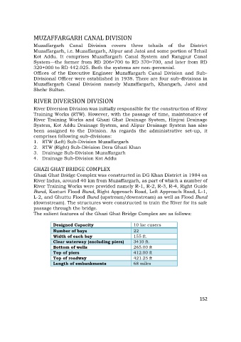
The salient features of the Ghazi Ghat Bridge Complex are as follows:
Designed Capacity 10 lac cusecs
Number of bays 22
Width of each bay 155 ft.
Clear waterway (excluding piers) 3410 ft.
Bottom of wells 265.00 ft
Top of piers 412.00 ft
Top of roadway 421.25 ft
Length of embankments 68 miles
152